|
Fragile margin or island Arcadia?
The making of the (pre)historic Maltese islandscape Dr Gianmarco Alberti (Research Support Officer) Dr Reuben Grima Dr Nicholas Vella Research Questions The study of small islands has often been dominated by debates on marginal environments, which can only support fragile and vulnerable subsistence strategies, and are prone to environmental stress. The Maltese islands are no exception, and fragility and marginality have loomed large in approaches to the productivity of the islands, during prehistory as well as during more recent periods. In a review of ancient, medieval and early modern written references to the productivity of the Maltese islands, Dr Brunella Bruno (2004) has noted that these can vary widely in their accounts of how fertile the Maltese islands are. |
This report in a words cloud
|
Part of the explanation for this apparent contradiction may be that productivity cannot be assessed in absolute terms in isolation from a cultural context. On the contrary, it is inseparable from the specific subsistence strategies being practiced in a given situation, and how well-adapted these are to the environmental constraints and opportunities (Walsh 2014).
|
As underlined by Horden and Purcell (2000), a key characteristic of Mediterranean landscapes is what has been described as ‘fragmentation’, resulting in dramatic changes in environmental affordances over very short distances. As they are at pains to underline, subsistence microstrategies that are developed to cope and take advantage of this fragmentation may prove rather more sustainable than one may expect in what may, a priori, seem like a very inhospitable environment. In the context of the interdisciplinary work being undertaken in the FRAGSUS project, our work revisits the question of productivity of the land, using evidence from more recent historic periods, while however examining issues that lie at the basis of any discussion of fragility and sustainability in a small island setting.
The work done (which is very much a work in progress) focuses on an extensive archival record of all government–owned property in Malta conducted in the 1860s, which provides a detailed snapshot of land-holding in early modern Malta, as well as of perceived land quality at the time of the survey (Figs 1-2). |
|
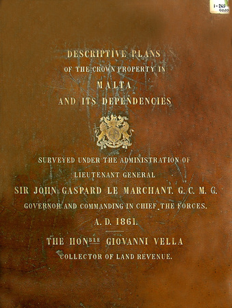
Fig. 1: 1861 Cabreo front cover
|
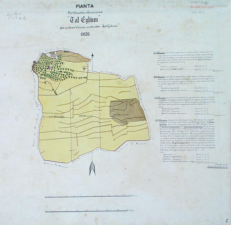
Fig. 2: Example of Cabreo map, with colours according to different terrain qualities
|
Methodology and Preliminary Results
As this data is in cartographic form, which could be spatially correlated, it has proved possible to undertake for the first time a GIS-based analysis of this archival material, the first results of which are presented here. The Cabreo maps have been georeferenced in a GIS platform within a geodatabase, devoted to the Maltese archipelago, which is under development at the GIS Laboratory of the Department of Classics and Archaeology. It must be noted that the georeferencing process has been particularly time-consuming (taking several months, between March and July 2014) because, in lack of any geographic coordinate, the individuation of elements on the maps that could be used as referencing points against a georeferenced base-map has been done by a painstaking visual matching process. As a result, we have been eventually able to give spatial references the majority of the available Cabreo’s parcels (43), excluding few very small ones. For the purpose of the model building, a further preliminary step has been taken. The georeferenced maps have been digitized in ArcGIS 10.1 with the use of vector polygons, and the quality class of each parcel has been entered into the polygons’ attribute table. The vectorialization of the parcels has also made it possible to obtain a figure of the total area covered by the data generated from the Cabreo (6.20 sq Km), which corresponds to 9.42% of the overall area of Gozo (65.78 sq Km) (Figs 3-5).
As this data is in cartographic form, which could be spatially correlated, it has proved possible to undertake for the first time a GIS-based analysis of this archival material, the first results of which are presented here. The Cabreo maps have been georeferenced in a GIS platform within a geodatabase, devoted to the Maltese archipelago, which is under development at the GIS Laboratory of the Department of Classics and Archaeology. It must be noted that the georeferencing process has been particularly time-consuming (taking several months, between March and July 2014) because, in lack of any geographic coordinate, the individuation of elements on the maps that could be used as referencing points against a georeferenced base-map has been done by a painstaking visual matching process. As a result, we have been eventually able to give spatial references the majority of the available Cabreo’s parcels (43), excluding few very small ones. For the purpose of the model building, a further preliminary step has been taken. The georeferenced maps have been digitized in ArcGIS 10.1 with the use of vector polygons, and the quality class of each parcel has been entered into the polygons’ attribute table. The vectorialization of the parcels has also made it possible to obtain a figure of the total area covered by the data generated from the Cabreo (6.20 sq Km), which corresponds to 9.42% of the overall area of Gozo (65.78 sq Km) (Figs 3-5).
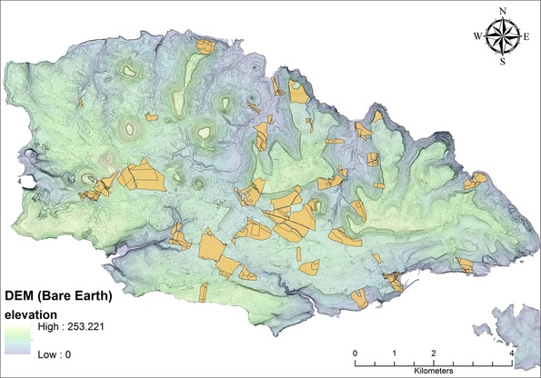
Fig. 3: Spatial coverage of the georeferenced Cabreo maps, which are displayed in orange (underlying raster: slopeshade map obtained from a LiDAR-derived bare-earth DEM)
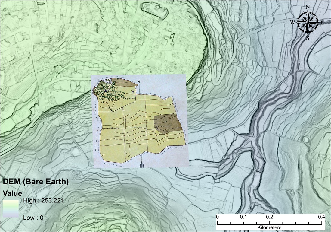
Fig. 4a: Georefered Cabreo map (underlying raster: slopeshade map obtained from a LiDAR-derived bare-earth DEM)
|
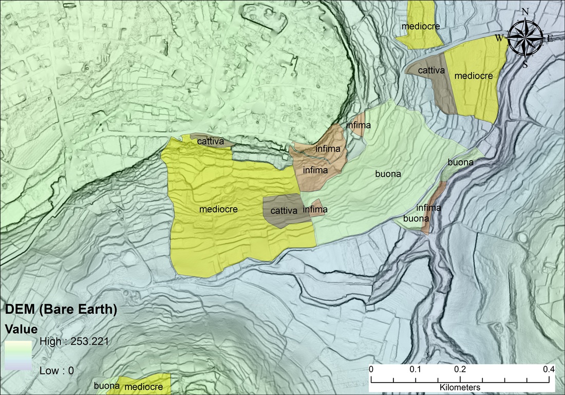
Fig. 5: Cabreo maps vectorialized [parcels' quality attributes (in Italian) are also shown]
|
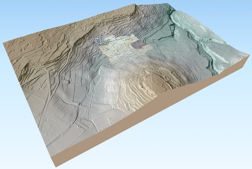
Fig. 4b: 3D view of the Cabreo parcel portrayed in Fig. 4a. See also Fig. 10a-b further below.
The main, yet preliminary, goal of the work is to assess what variables (if any) affect the land quality as empirically classified in the Cabreo maps. In a GIS framework, Logistic Regression (see, e.g., Alberti 2014) has been used to model the relationship between different environmental/topographic variables (for some of them, see Figs 6-8) and the outcome of a nominal dependent one (i.e., Cabreo land quality classes).
Fig. 6: Example of the GIS raster layers used as Independent Variable into the Logistic Regression model: terrain elevation above sea level
|
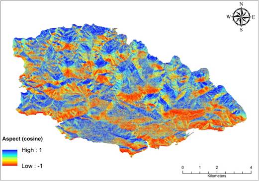
Fig. 7: Example of the GIS raster layers used as Independent Variable into the Logistic Regression model: aspect (cosine)
|
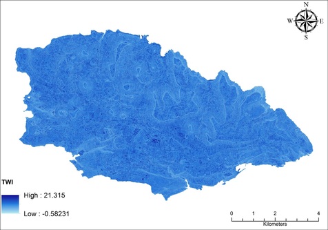
Fig. 8: Example of the GIS raster layers used as Independent Variable into the Logistic Regression model: Topographic Wetness Index
|
Logistic Regression is widely used in different research fields, spanning from anthropology and archaeology to hard sciences. Since the technique allows to model the relation between a nominal dependent variable and independent variables of different types (nominal and/or continuous), it is not by chance if it finds extensive use in GIS-based studies aimed at assessing the influence of different environmental or topographic variables on different outcomes of a nominal dependent one (e.g., presence/absence of landslides). To put it in a nutshell, Logistic Regression allows estimating the probability that a particular outcome of a dependent nominal variable (y) will occur based on information from one or more explanatory variables (x). The technique ultimately finds the equation that best predicts the probability p of getting a particular value of y, with p taking values from 0.0 to 1.0. |
More plainly, the equation returned by Logistic Regression consists of values of the independent variables plus weights estimated by the model to predict the outcome of the dependent variable. As consequence, once logistic regression has been ran, and the intercept and coefficients have been found, one is in the position to derive the probability of the outcome of y by plugging those parameters and any known value of the various independent variables into the logistic regression equation.
While many interrelated variables are likely to influence soil quality in terms of suitability for agriculture - including chemical features, salinity and sodicity levels, soil texture, internal drainage, winds, precipitation and climate - the selected variables have been deemed as potentially important for the parcels’ quality since they are linked, although in different ways, to what appears to be the key factor for the understanding of the distribution patterns of vegetation and human activities in the Maltese archipelago, that is the availability of water both in terms of fresh water and moisture retained by the terrain.
The model has made it possible to pinpoint a host of variables that significantly influence the probability for any spot on the ground to be ‘optimal’ as opposed to 'non optimal' on the basis of the Cabreo data (Fig. 9).
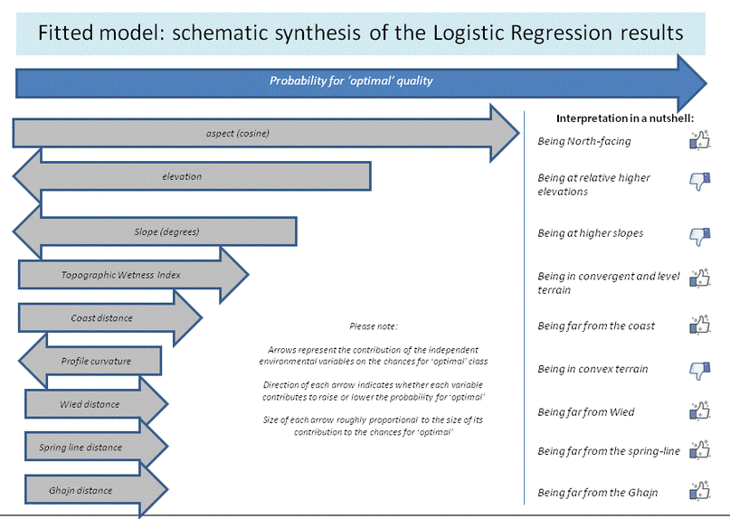
Fig. 9: Schematic summary of the results of the fitted Logistic Regression model for Gozo's land quality as derived from Cabreo data. Arrows represent the contribution of the independent variables on the chances for 'optimal' land quality. Direction of each arrow indicates whether a variable contributes to raise or decrease the chances for 'optimal' land quality. Size of each arrow is roughly proportional to the size of each variable's contribution to the chances for 'optimal' land quality
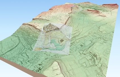
Fig. 10a: 3D view of the fitted Logistic Regression model wrapped over a bare earth DEM; color scale ranging from green (highest probability for optimal land quality) to red (lowest probability for optimal land quality). Two Cabreo parcels are wrapped over the DEM as well (foreground: parcel near Santa Verna; background: parcel between Gjgantia and Nuffara). See also Fig. 10b
-click the image to explore it in full 3D-
|
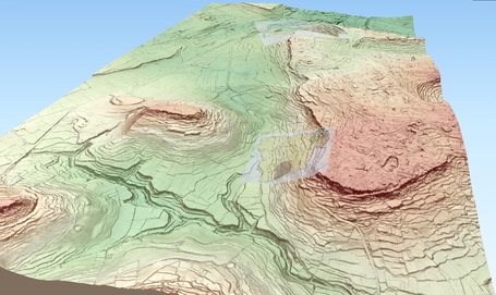
Fig. 10b: same as Fig. 10a, viewed in the opposite direction
-click the image to explore it in full 3D-
|
Another interesting achievement of the analysis is the possibility to assess the relation between the probability for 'optimal' land quality, as predicted by the fitted Logistic Regression model, and the soil types as classified by Lang in his book ‘Soils of Malta’ published in the 1960s. As shown below (Fig. 11), a good correspondence may be seen between some observations made by Lang on soil types' agricultural suitability and the land quality as predicted by the fitted model. In particular, it is worth noting that the two soil types occurring in terrains with the higher average probability for ‘optimal’ quality class, that is Brown Rendzinas and Xerorendzinas, are those reported by Lang as giving satisfactory crops.
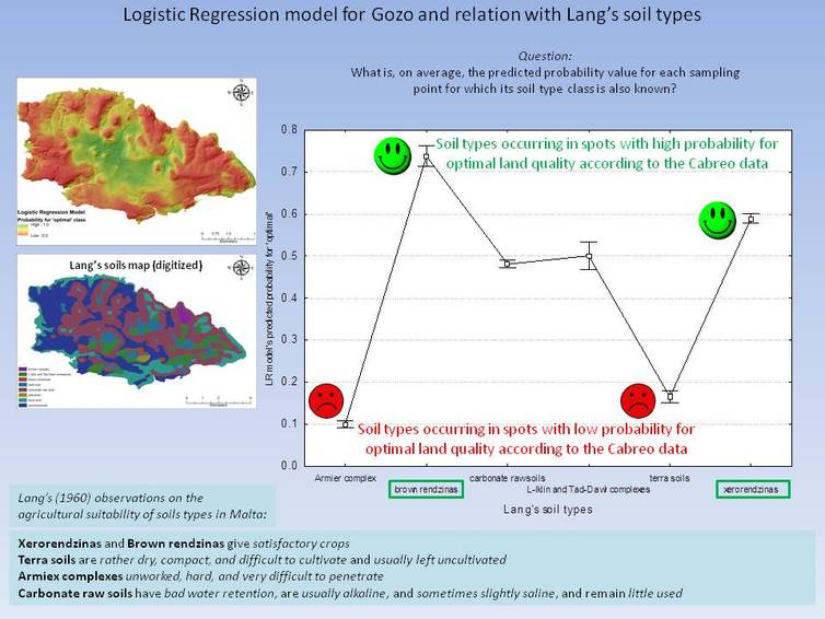
Fig. 11: Relation between the results of the fitted Logistic Regression model and Lang's (1960) remarks on soil types agricultural suitability
Future Research
Our work has focused on the work conducted to date to use historic documentation of early modern landscapes in order to generate statistically robust quantitative models. The results obtained so far demonstrate the viability of such an approach, which will continue to be developed in the coming months.
The most immediate objective, which is already being achieved, is to provide a better-informed model of which variables helped determine the quality, or perceived quality, of terrain for agriculture in the modern period. This analysis, to date confined to the island of Gozo, will be extended to incorporate the entire archipelago in the coming months. A further objective is that the model being developed will become a useful baseline that will allow a more informed approach to evidence for earlier periods, from prehistory onwards.
The results of the logistic regression model are also raising new questions which require further investigation. One example is that the results have underlined how the characteristics considered favourable for agriculture may be very different to those that favour settlement (e.g. distance form springs). This in itself is a useful result, not least because it suggests caution is required when using prehistoric settlement evidence as a proxy indicator of agricultural exploitation.
Another objective is to develop the tools to permit the quantitative exploration of different cultural responses to fragmented landscapes across time. The results achieved so far have suggested several avenues for further investigation in this respect, which will continue to be explored in the coming months.
Acknowledgments
The University of Malta FRAGSUS team is grateful to the National Archives (Malta) for facilitating access to the Cabreo maps for the research presented here. The Digital Terrain Model used in the process of model building was derived from the LiDAR data made available through an agreement signed between the University of Malta and the Malta Environment and Planning Authority in 2013. We acknowledge the source: ERDF LIDAR data, 2012, ERDF156 Developing National Environmental Monitoring Infrastructure and Capacity, Malta Environment and Planning Authority.
Website design and maintenance: Gianmarco Alberti
