Taken by storm?
Scientific investigations into Malta’s past environment
Scientific investigations into Malta’s past environment
|
Dr Katrin Fenech (Research Support Officer)
Prof Patrick J. Schembri Dr Nicholas Vella Research Questions The environment of the Maltese Islands prior to the arrival of the first settlers in the Neolithic is generally thought to have been extensively forested. The introduction of agriculture by the first settlers is then believed to have put an end to the perceived Garden of Eden through intensive tree felling and slash-and-burn to gain precious agricultural land for crops (Grech 2001). |
This report in a words cloud
|
The subsequent erection of the megalithic structures, commonly referred to as ‘temples’, all over the islands coupled with a controversial estimate of a total population of 10,000 people in the Temple Period (Renfrew 1973) is thought to have been a recipe for disaster. The sheer number of inhabitants would have led to the downfall of this early civilization through over-exploitation of the environment, leading to severe erosion, possibly followed by prolonged drought that led to famine (Bonanno 1986), resulting in the mysterious vanishing of the Temple people. Possibly. Godwin (1961) concluded through pollen analysis of samples from a Bronze Age pit that the Bronze Age environment then was ‘already’ very much like it is today. However, Schembri et al. (2009) found through analysis of molluscan remains from the Xagħra Circle in Gozo that ‘already’ in the Żebbuġ phase the environment was open country/steppe-like, very much like today’s environment.
Whether there ever was a ‘forest’ and whether it was human impact on the environment or climate and weather or an unfavorable combination of the two that led to the demise of the Neolithic culture in the Maltese Islands is one of the questions FRAGSUS aims to answer. In a first effort to address this question, we made a scientific study of the sediments and the molluscan remains of a sediment core that had been retrieved from Marsa in 2002 as part of other work.
Whether there ever was a ‘forest’ and whether it was human impact on the environment or climate and weather or an unfavorable combination of the two that led to the demise of the Neolithic culture in the Maltese Islands is one of the questions FRAGSUS aims to answer. In a first effort to address this question, we made a scientific study of the sediments and the molluscan remains of a sediment core that had been retrieved from Marsa in 2002 as part of other work.
Material and Methods
In 2002, two usable cores had been taken thanks to the financial sponsorship of Ms Linda Eneix through the OTS Foundation. Of these, Marsa Core 1 was sectioned into slices 5 cm thick and the contents of each divided in half. The resulting samples of these divided segments were then subjected to extensive investigations between 2002 and 2007, forming the basis of two PhD studies, one by Frank Carroll (Queen’s University Belfast) and the other by Katrin Fenech (University of Malta). Carroll conducted a number of physical and chemical investigations and analysed the pollen content of every fifth sample. Fenech based her analyses on broad granulometry, molluscan analysis, and that of plant macro-remain of every single section. The results from Core 1 were very promising and provided a lot of information about the past environmental history of the Maltese Islands, although the interpretations of the two studies differed. The results have since been published (Carroll et al. 2012; Fenech 2009).
As part of the FRAGSUS project, Fenech’s half of Core 2 was investigated using the same methodology as for Core 1. The site of Core 2 was located roughly 43 m to the north of Core 1 (Fig. 1) and showed in the stratigraphy similarities as well as some differences. The aim was to get fresh data from Malta’s largest water catchment, to compare and contrast the findings with Core 1 and, through radiocarbon and other dating, to put the results into a chronological context, something that was only partially possible when Core 1 was analysed.
The method applied was exactly the same as for Marsa Core 1 to facilitate comparison (Fenech 2009).
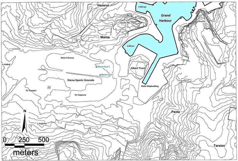
Fig. 1: Marsa’s alluvial plain and the location of the boreholes for Marsa Core 1 and Marsa Core 2.
Results from Marsa Core 2
Marsa Core 2, Section I, 9.40 m (bedrock interface) to 6.40 m (Fig. 2).
Date very tentatively Late Pleistocene to Early Neolithic, based on circumstantial evidence. The bedrock interface may extend to around 9.05 m, then several wash-over and erosion events followed throughout. The samples were generally poorly sorted, occurrence of stones >8 mm was common. The gap was due to a large boulder that may have been the result of a severe erosion/ storm event. The soil colours of the samples indicate aerobic conditions (i.e. not submerged under water), variations in the soil colours further indicate events. Dark soil colours coincided with high levels of silt/clays. The actual amount of shells found was very small (highest amount at 7.00-7.05 m were 20 shells (standardised to per 150g sample). Brackish water shells (blue) may indicate wash-over events from the close shore, land snails (green) may indicate erosion events that washed them to the sampling site. Euhaline (marine, black) species occurred only once. The presence of organic remains was sporadic, charcoal and seeds were rare (not more than a few microscopic fragments), plant remains were occasionally frequent and often coincided with the occurrence of land snails. The erosion indicator species Cecilioides acicula occurred twice, confirming erosion events. The uppermost sample of this section, between 6.45-6.40 m, contained an unusually high amount of windblown quartz.
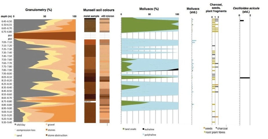
Fig. 2: Results from Marsa Core 2, Section I bedrock interface to 6.40m. Date possibly Late Pleistocene to ?Early Neolithic.
Marsa Core 2, Section II, from 6.40 m (with overlap from Section I) to 4.45 m, Fig. 3.
Date possibly Neolithic to Late Bronze Age/early Phoenician. Two sherds of prehistoric pottery belonging to the same (unknown) ware-type (Fig. 4) were found at 6.10-6.15 m and at 5.05-510 m, while carbonised grape seeds were found at 4.75-4.80 m and 4.50-4.55 m respectively. Erosion episodes appeared to decrease up to 6.35 m, the molluscs found up to this level were few. There was then an increase in the number of land snails and a dramatic increase in the number of brackish water molluscs. This coincides with a very sudden and drastic change in the sediment colour indicating anoxic and brackish water conditions from 6.45 m. The next remarkable change occurred at 6.25-6.30 m, as indicated by a change in all categories under investigation. Terrestrial erosion is indicated by an increase in land snails including the erosion indicator species Cecilioides acicula, and organic content up to the gap. A storm event as a source of the heavy erosion is possible as also marine molluscs were on the increase. Charcoal was remarkably abundant at 6.15-6.20 m. The possibly disastrous fire represented by this may have facilitated the ensuing erosion as evidenced by a subsequent increase in particles > 63 microns, in land snails, the first appearance of freshwater shells and the presence of Cecilioides acicula. At this level, 6.10-6.5 m, a prehistoric pottery sherd with distinctive incision was found, which could possibly give a tentative Neolithic date to a potentially massive erosion event. Variations in all categories continue and conform with each other, e.g. a decrease in silt/clay was accompanied by an increase in land and freshwater snails. Also at 5.95-6.00 m abundant charcoal was found. The land snails washed into this sample still showed encrustations of terra rossa, which may indicate the velocity and suddenness with which these shells were transported and buried. Variations in the colour of the 63 micron fraction may attest further the severity of the erosion. The 70 cm gap between 5.90-5.20 m occurred because the sediments were too sandy to be retained by the corer, indicating a massive storm deposit that finds its upper peak at 5.05-5.10 m with a large amount of land snails including many Cecilioides acicula, and freshwater molluscs. This sample contained the same kind of prehistoric pottery that was found way below at 6.10-6.15 m. From 4.95-5.00 m onwards, comparatively calmer conditions are indicated by a large increase in brackish water molluscs and the relatively small amount of land snails. That erosion and storm events still affected the area of the core is indicated by the granulomety, the presence of Cecilioides acicula (although in smaller numbers than before), the frequent occurrence of charcoal, seeds and plant remains and the occurrence of freshwater molluscs and marine (euhaline) species. The sedimentation rate between 5.00 and 4.50 m may have been relatively low if indeed the carbonised grape seed found at 4.75-4.80 m can be dated to the Late Bronze Age/early Phoenician period. Should the grape seed be dated to a later period, the sedimentation rate would have been even lower.
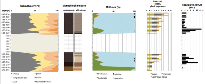
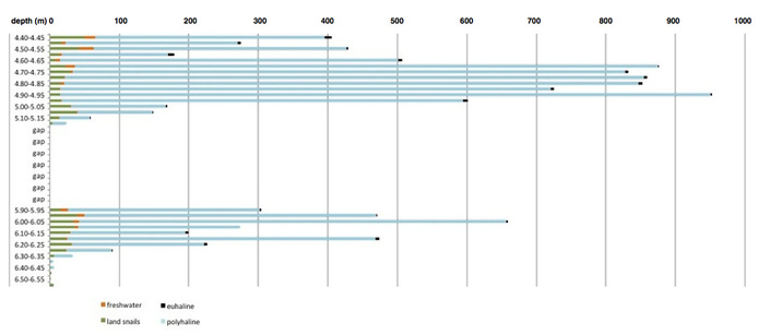
Fig. 3: Results from Marsa Core 2, Section II, from 6.40m (with overlap from Section I) to 4.45m. Date possibly Neolithic to Late Bronze Age/ early Phoenician. Number of molluscs by broad habitat categories, standardised to 150g/ sample. Polyhaline species include euryhaline species and form the brackish water group.
|
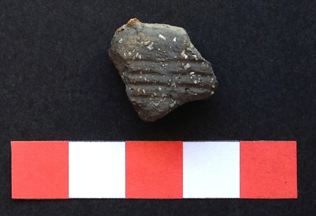
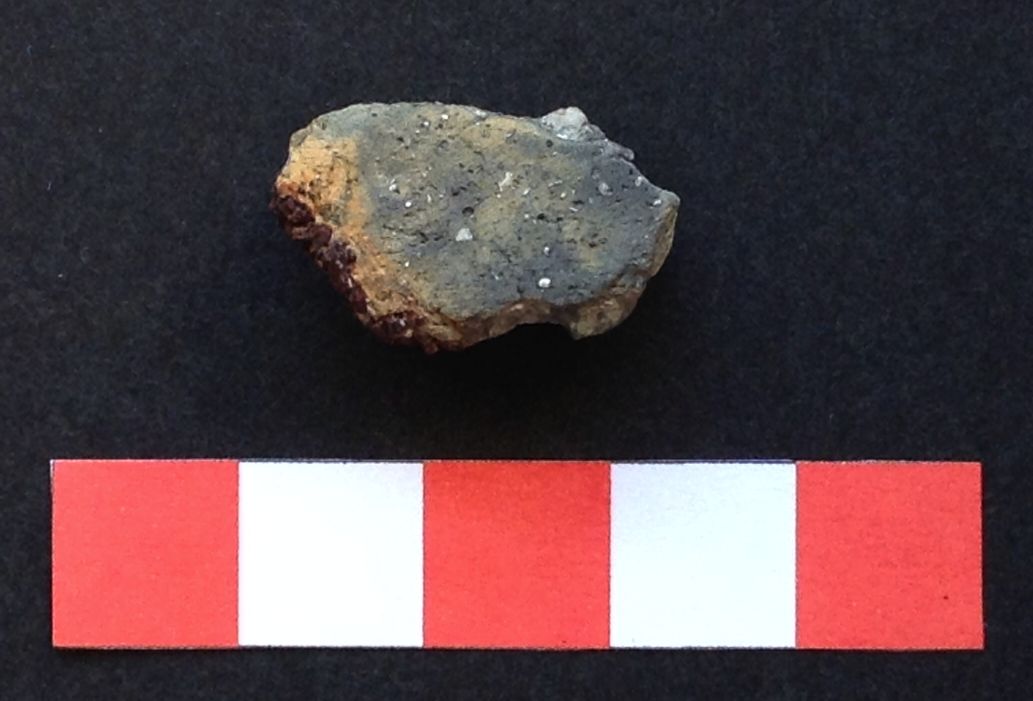
Fig. 4: Prehistoric pottery found in Marsa Core 2. Top: pottery fragment with incisions found at 6.10-6.15m, bottom: undiagnostic pottery fragment of the same unknown ware type as above, found at 5.05-5.10m. Scale in cm.
|
Marsa Core 2, Section III, from 4.55 m to 3.05 m, Fig. 5
Very tentatively dated to Late Bronze Age/early Phoenician to Medieval Malta by the carbonised grape seed found at the base and two possibly medieval amphora sherds found between 3.70-3.80 m. This section is marked by periods of relatively stable conditions with comparatively low sedimentation rates in a former lagoon environment if this section indeed covers around 2000 years. No stones have been washed into the coring site and although there are variations in the smaller fractions, this appeared to have little influence on the moist soil colour, where only one major change noted. Up to 4.25 m terrestrial erosion occurs, washing land and freshwater snails into the lagoon, including the burrowing snail Cecilioides acicula. The organic content, particularly of charcoal and plant fragments remained high. Between 4.30-4.20 m erosion appears to have been comparatively insignificant. At 4.15-4.20 m there was a marked increase in the amount of land and freshwater snails, as well as a few Cecilioides acicula. As this is not markedly reflected in the granulometry, the influx of these snails may have been due to wetter conditions but not necessarily extreme storm events. From 4.20 m until 3.95 m Cecilioides acicula were prominent, while the amount of land- and freshwater shells decreased moderately. Organic remains were abundant at the same time and there was a high number of seeds (up to 20 seeds) between 4.20-3.90 m, with more than 50 seeds at 4.00 m. The overall number of shells found in the sediments was also rather high. There was a change in the sediment colour at 3.80-3.85 m. Erosion appears to have henceforth decreased, as indicated by the absence of Cecilioides acicula, as well as by a marked decrease in the land- and freshwater snails. Between 3.80-3.70 m two pottery sherds belonging to the same amphora of probably Central Tunisian origin were found (Fig. 6). The sherds had a pale yellow glaze with splashes of bluish green, date unknown but possibly 8th century (pers. comm. Maxine Anastasi, University of Oxford, UK). This amphora appears to have been broken in situ as small, sharp breakage flakes were also present in the samples. Smaller erosion episodes continue up to 3.05 m at irregular intervals, increases in freshwater and land snails may have been due to increased runoff transports, which also would have transported the organic remains into the sea. Granulometry shows a gradual decrease in >500 micron particles and an increase in silt/clays in the upper half of this section. Sedimentation rates may have increased here as the overall number of shells found in the upper part decreased markedly. The presence of marine (euhaline) molluscs may have been due to either isolated storm events or inundations of the lagoon by marine waters.
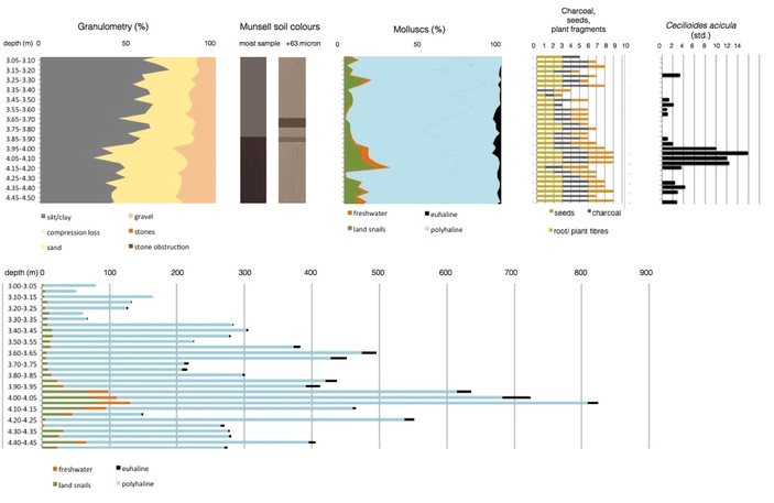
Fig. 5: Results from Marsa Core 2, Section III, from 4.55m to 3.05m. Very tentatively dated to Late Bronze Age/ early Phoenician to Medieval Malta by carbonised grape seed found at the base and two medieval amphora sherds found between 3.70-3.80m. Number of molluscs by broad habitat categories, standardised to 150g/ sample. Polyhaline species include euryhaline species and form the brackish water group.
|
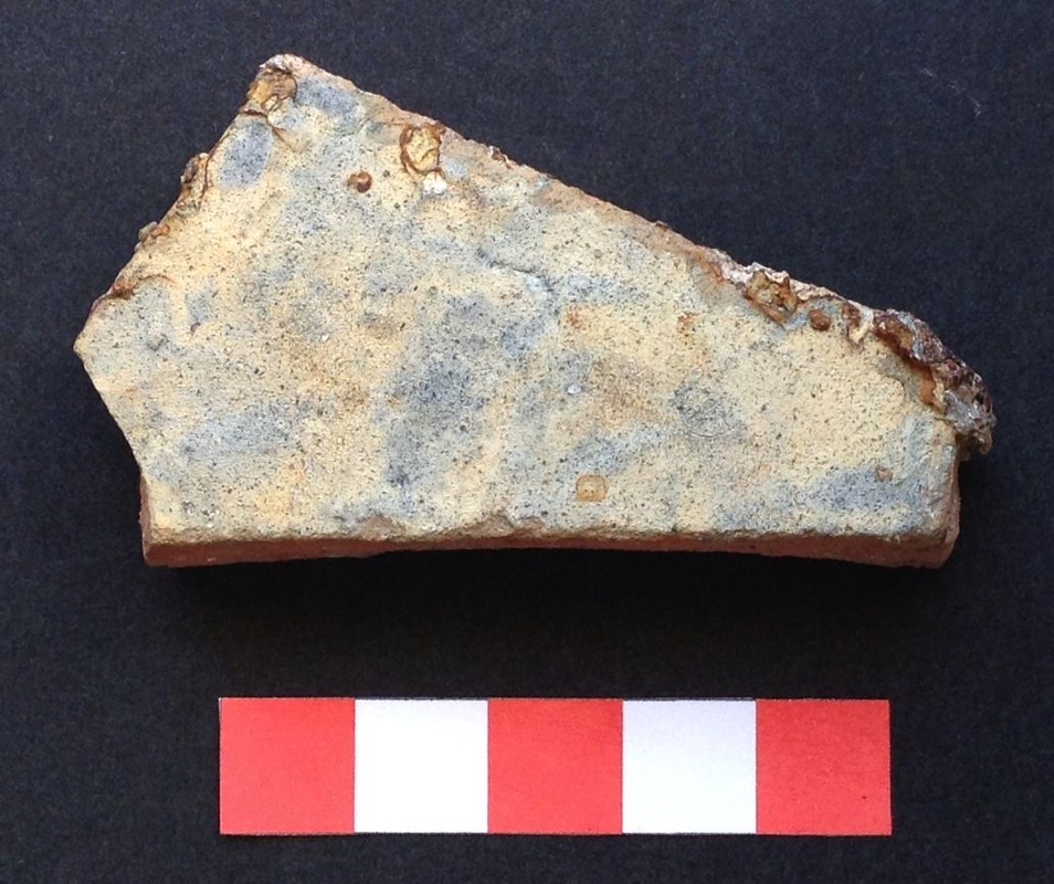
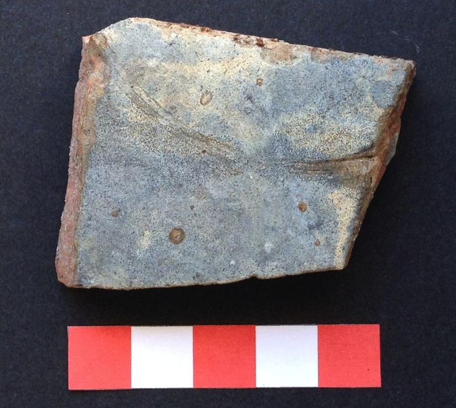
Fig. 6: Medieval Amphora sherds of probably central Tunisian origin found in Marsa Core 2 at 3.75-3.80m (top) and 3.70-3.75m (bottom), belonging to the same amphora. Scale in cm.
|
Marsa Core 2, Section IV, from 3.15m to top, Fig. 7
Date unknown, speculatively from 13th century to British Period. This section is dominated by two major events that led to the deposition of large boulders at the coring site, burying the silts below them. After a period of relative stability up to 2.85 m, there is a strong and sudden influx of stones. The number of shells was very low but there were land snails, brackish water and marine (euhaline) species in fairly equal proportions, possibly pointing to a major event that starts at 2.70 m. It is possible that this is not a storm deposit due to the sudden appearance of very large stones, lack of organic content and absence of Cecilioides acicula. Furthermore, the stones found appear to have been worked and may have been part of a building or artefact (Fig. 8). They may have been dumped intentionally or could have tumbled as a result of a collapsing building. The deposition of the large boulder would have resulted in a time-gap until it was covered by sand and silt again at 2.20 m. Conditions then still appeared lagoonal as evidenced by the soil colours and the presence of a few brackish water snails. At 1.95 m a major storm event appears to have gained momentum. The granulometry showed an increase in the particle size, the soil colours turned markedly lighter, there was a steep rise in the percentage and number of land- and freshwater shells and organic content. The burrowing land snail Cecilioides acicula was also present. Again a large stone obstruction resulted in a gap in the data. The fining up of the grain sizes on top of the stone obstruction at 1.20 m may indicate the continuation of the storm event up to 1.10m. Shells consisted of land- and freshwater shells only, including Cecilioides acicula. Plant fragments and charcoal were frequent. At 0.95-1.00 m the soil colour markedly changed, indicating that the lagoonal phase was over and the area is above sea level. The freshwater influence is over by 0.85-0.90 m. The gap between 0.80-0.30 cm was due to a wet and sandy deposit, which could not be retained by the corer. It is unclear whether this is related to the present day sea-level or to an event. The topmost part of the core is likely to be disturbed due to the building activity that took place on site at the time of coring.
Date unknown, speculatively from 13th century to British Period. This section is dominated by two major events that led to the deposition of large boulders at the coring site, burying the silts below them. After a period of relative stability up to 2.85 m, there is a strong and sudden influx of stones. The number of shells was very low but there were land snails, brackish water and marine (euhaline) species in fairly equal proportions, possibly pointing to a major event that starts at 2.70 m. It is possible that this is not a storm deposit due to the sudden appearance of very large stones, lack of organic content and absence of Cecilioides acicula. Furthermore, the stones found appear to have been worked and may have been part of a building or artefact (Fig. 8). They may have been dumped intentionally or could have tumbled as a result of a collapsing building. The deposition of the large boulder would have resulted in a time-gap until it was covered by sand and silt again at 2.20 m. Conditions then still appeared lagoonal as evidenced by the soil colours and the presence of a few brackish water snails. At 1.95 m a major storm event appears to have gained momentum. The granulometry showed an increase in the particle size, the soil colours turned markedly lighter, there was a steep rise in the percentage and number of land- and freshwater shells and organic content. The burrowing land snail Cecilioides acicula was also present. Again a large stone obstruction resulted in a gap in the data. The fining up of the grain sizes on top of the stone obstruction at 1.20 m may indicate the continuation of the storm event up to 1.10m. Shells consisted of land- and freshwater shells only, including Cecilioides acicula. Plant fragments and charcoal were frequent. At 0.95-1.00 m the soil colour markedly changed, indicating that the lagoonal phase was over and the area is above sea level. The freshwater influence is over by 0.85-0.90 m. The gap between 0.80-0.30 cm was due to a wet and sandy deposit, which could not be retained by the corer. It is unclear whether this is related to the present day sea-level or to an event. The topmost part of the core is likely to be disturbed due to the building activity that took place on site at the time of coring.
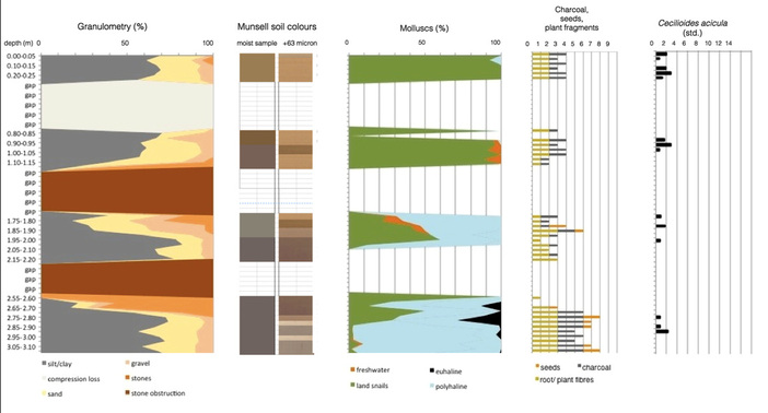
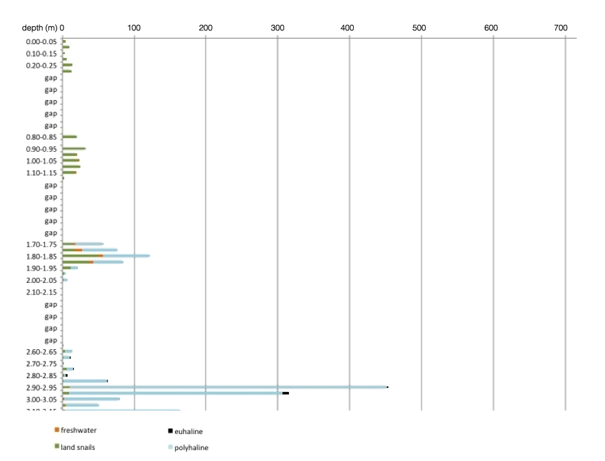
Fig. 7: Results from Marsa Core 2, Section IV, from 3.15m to top. Date unknown, speculatively from 13th century to British Period. Number of molluscs by broad habitat categories, standardised to 150g/ sample. Polyhaline species include euryhaline species and form the brackish water group.
|
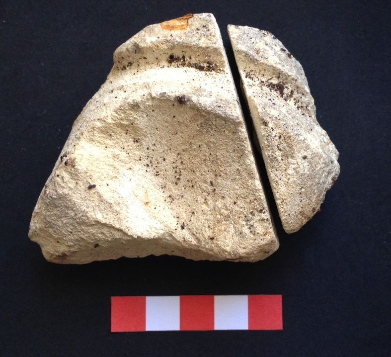
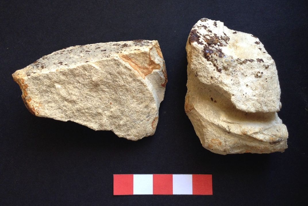
Fig. 8: Stones found in the core preceding the stone obstruction at 2.65-2.70m (2/27, top) and 2.55-2.60m (2/25, bottom). Both stones appear to have been worked.
|
Future Research
It appears that several strong sedimentation events occurred in Malta’s past. The compression loss that occurred in the lowermost section is likely to have been the result of one massive event that possibly happened in the late Neolithic. However, in the absence of any radiocarbon dates from this core, this is purely speculative. Once a sufficient number of radiocarbon dates are available it would also be possible to link the data with the data obtained of Core 1 and thus help to provide the answers sought by FRAGSUS.
References
Bonanno, A. (1986) A Socio-Economic Approach to Maltese Prehistory – the Temple Builders. Malta, Studies of its Heritage and History, pp. 17-46. Malta: Mid-Med Bank Ltd.
Carroll, F.A., Hunt, C.O., Schembri, P.J. and Bonanno, A. (2012) Holocene climate change, vegetation history and human impact in the Central Mediterranean: Evidence from the Maltese Islands. Quaternary Science Reviews 52: 24–40.
Fenech, K. (2009) Human-Induced Changes in the Environment and Landscape of
the Maltese Islands from the Neolithic to the 15th Century AD as Inferred from a Scientific Study of Sediments from Marsa, Malta. Oxford: BAR International Series 1682.
Godwin, H. (1962) Appendix I, Report on a pollen sample from a late Borġ in-Nadur cistern at Tal-Mejtin. Report on the working of the Museum Department for the year 1961 p. 8. Malta: Department of Information.
Grech, C.F. (2001) A History of the Maltese Forest until 1800 AD. Unpublished PhD dissertation. University of Aberdeen.
Giusti, F., Manganelli, G. and Schembri, P.J. (1995) The non-marine molluscs of the Maltese Islands. Torino: Museo Regionale die Scienze Naturali.
Renfrew, C. (1973) Before Civilization. London: Penguin Books.
Schembri, P., Pedley, M., Hunt, C.O., Stoddart, S. (2009) The environment of Malta and Gozo and of the Xaghra Circle. Mortuary customs in Prehistoric Malta, edited by C. Malone, S. Stoddart, A. Bonnanno, D. Trump, pp. 17-39. Cambridge: Cambridge University Press.
Website design and maintenance: Gianmarco Alberti
